
Routes2Ride
Paisley and Clyde Railway Path
Starting at Paisley you’ll pass the town of Johnstone, where National Routes 7 & 75 separate, and then cross attractive open country on railway path between the Bridge of Weir and Kilmacolm, before reaching Port Glasgow and Greenock on the Firth of Clyde. Ferries ply between Gourock and Dunoon, a gateway to the Cowal Peninsula area of the Loch Lomond and the Trossachs National Park. There are some steep gradients in Port Glasgow and Greenock.
Classification: Moderate Distance: 21 miles
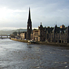
Perth to Almondbank & Pitcairngreen
This leisurely pedal to Almondbank weir is mainly traffic-free and is punctuated by some impressive views. You begin the ride on the North Inch in Perth alongside the River Tay, Scotland’s longest river, and follow it for nearly 2½ miles before turning alongside the River Almond. Your ride can finish at Almondbank where the riverbank becomes more wooded and salmon fishing is a popular pastime or continue along a minor road to the village of Pitcairngreen.
Classification: Suitable for families Distance: 6 miles
Perth to Dunkeld
This gentle ride takes you between two fascinating places, there are no major climbs, and you can take the train back to your starting point. Leaving the North Inch in Perth, you follow cycle paths alongside the River Tay and get splendid views of Scone Palace, where Scotland’s kings were crowned. You then follow tracks beside the River Almond, passing close by Huntingtower Castle, before reaching Almondbank and continuing to Dunkeld.
Classification: Easy Distance: 16½ miles
Tayport to Broughty Ferry
From Tayport a railway path follows the southern shore of the Firth of Tay to the Tay Road Bridge which is crossed using the elevated cycle path in the centre of the bridge. On the Dundee side of the bridge a lift takes you and your bike down to ground level and to the route through Dundee Docks (security pass required). The traffic-free shoreline promenade and quiet roads lead to Broughty Ferry and Broughty Castle.
Classification: Suitable for families Distance: 8 miles
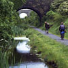
Union Canal - Linlithgow to Falkirk Wheel
The route starts in Linlithgow on the Union Canal close to the Railway Station and the Linlithgow Canal Centre. West of Linlithgow the route is wonderfully rural, following the towpath along the northern bank of the canal. Follow the towpath over the Avon Aqueduct and through the half-mile long Falkirk Tunnel (bring lights!) all the way to the Falkirk Wheel, where the Union Canal joins the Forth & Clyde Canal.
Classification: Easy Distance: 12 miles
Union Canal - Linlithgow to Ratho
The route starts in Linlithgow on the Union Canal close to the Railway Station and the Linlithgow Canal Centre. Beyond Linlithgow, the route is mainly rural following the towpath east along the northern bank of the canal, close by Niddry Castle, through Broxburn, over the Almond Aqueduct, past the Scottish National Climbing Centre and into Ratho.
Classification: Suitable for families Distance: 13 miles
Union Canal - Water of Leith
This traffic-free journey starts by following the Water of Leith path from Balerno into Slateford, using a disused railway and tunnel. It then joins the Union Canal into central Edinburgh, crossing the Water of Leith on an aqueduct.
Classification: Suitable for families Distance: 7 miles
Lochwinnoch Loop Line
From Paisley Canal station the route goes to Johnstone, following the traffic-free railway path. From there it heads to Kilbarchan, Lochwinnoch and Kilbirnie, passing by three lochs and a Site of Special Scientific Interest. Castle Semple Visitor Centre is an excellent location for water sports, walks, cycling and picnics. There is wheelchair access to the whole route.
Classification: Easy Distance: 14 miles
Kincardine - Charlestown
The route starts just to the east of the old Kincardine Bridge and picks up the “pipe track” into Culross, a 17th Century town worth exploring. The pipe track continues along the shore of the River Forth and past Preston Island. Continue on roads through Newmills and around Torry Bay – with excellent bird watching. There is a steep climb up to Crombie before a cycleway and a drop down a rough road bring you to Charlestown.
Classification: Easy Distance: 11 miles
Leuchars - Tayport
This ride begins in Leuchars. Follow National Cycle Network Route 1 on a quiet road out of the village to Tentsmuir Forest, which extends over the sand dunes between the estuaries of the Tay and the Eden. There is a picnic spot and access to the beach before the route heads to Tayport. Fife is criss-crossed with miles of cycle routes, many of them created as part of the Kingdom of Fife Millennium Cycleways.
Classification: Easy Distance: 8 ½ miles